A marine GPS chartplotter is an essential piece of marine electronics for boaters and fishermen. It combines numerous functions into a single display and can be found in various price ranges and sizes. We have reviewed the top marine GPS chartplotters available on the market, comparing their features, prices, and customer feedback to help you make an informed decision.
Key Takeaways:
- The best marine GPS chartplotters are essential navigation tools for boaters and fishermen.
- They come in various price ranges and offer different features to suit individual needs.
- When choosing a marine GPS chartplotter, consider factors such as price, size, and desired features.
- Customer reviews and feedback can provide valuable insights into the performance and reliability of different chartplotters.
- Top-rated marine GPS chartplotters from reputable brands ensure accurate and reliable navigation on the water.
What is a Marine GPS Chartplotter?
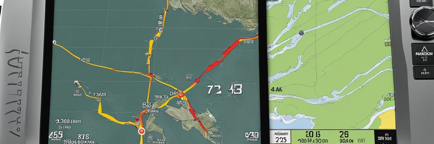
A marine GPS chartplotter is a versatile marine electronics device that combines the functionality of a GPS receiver and a chartplotter, offering accurate location information and navigation aids on a map display. This essential piece of equipment is widely used by boaters and fishermen to navigate waterways confidently and efficiently.
One of the key features of a marine GPS chartplotter is its ability to provide precise location information using GPS satellite signals. This information is then displayed on a chartplotter, allowing boaters to see their position in real-time on a detailed map. The chartplotter feature provides essential navigation tools such as waypoints, routes, and tracks, making it easier to plan and follow routes while on the water.
A marine GPS chartplotter can also be combined with a fishfinder to create a chartplotter fishfinder combo. This combination allows boaters and anglers to not only navigate accurately but also locate fish and underwater structures with ease. The fishfinder component uses sonar technology to detect fish and display them on the chartplotter screen, helping anglers identify optimal fishing spots.
Marine GPS chartplotters come in various sizes, from compact handheld units to larger fixed-mount displays suitable for larger boats. The display size and resolution are important considerations, as they impact the ease of viewing charts and information. Some chartplotters also offer touchscreen functionality for intuitive operation.
These devices offer a range of features designed to enhance the boating experience. They can provide weather updates, engine data display, and even AIS ship information. Additionally, advanced marine GPS chartplotters may offer network capabilities, allowing connectivity with other compatible marine electronics devices such as radars and VHF radios.
Key Functions and Features of Marine GPS Chartplotters:
- Accurate GPS location information
- Chartplotter for navigation aids
- Fishfinder functionality for locating fish
- Various display sizes and resolutions
- Touchscreen interfaces for user-friendly operation
- Weather updates and engine data display
- AIS ship information
- Network capabilities for connectivity
Price Range of Marine GPS Chartplotters:
The price of marine GPS chartplotters varies depending on factors such as display size, features, and brand. Entry-level chartplotters can be found in the range of $200 – $500, offering basic navigation functionality. Mid-range options typically cost between $500 – $1,000, providing a balance of features and performance. High-end marine GPS chartplotters, with larger displays and advanced features, can range from $1,000 and above.
| Price Range | Features | Examples |
|---|---|---|
| $200 – $500 | Basic navigation functionality | Brand A Model X |
| $500 – $1,000 | More features and performance | Brand B Model Y |
| $1,000 and above | Larger displays, advanced features | Brand C Model Z |
When choosing a marine GPS chartplotter, it’s important to consider your specific needs, budget, and the features that will enhance your boating experience. Whether you’re a recreational boater or a professional angler, a marine GPS chartplotter is an invaluable tool for accurate navigation and making the most of your time on the water.
How We Test Chartplotters
When it comes to testing chartplotters, we believe in thorough and comprehensive evaluations. Our team conducts extensive competitive analysis, comparing multiple units to provide accurate and reliable recommendations to our readers. We assess several important factors to ensure that the chartplotters we recommend meet the highest standards of performance and usability.
Screen Viewability
One crucial aspect we evaluate is the screen viewability of chartplotters under different lighting conditions. We test the displays to determine their readability and clarity, even in bright sunlight or low-light situations. A clear and easily visible screen is essential for efficient navigation.
User Interface and Navigation
An intuitive and user-friendly interface is key to efficient chartplotter operation. We carefully examine the user interface of each unit to assess its ease of use and accessibility of features. Smooth and logical navigation through menus and settings is crucial for seamless operation.
GPS Signal Reception
The chartplotter’s ability to receive and maintain accurate satellite position signals is critically important for precise navigation. We analyze the signal strength and its impact on the accuracy of position tracking to ensure reliable performance in various conditions.
Waypoint Management and Route Building
Efficient waypoint management and route building capabilities are essential for planning and executing trips. We assess the chartplotters’ ability to create, edit, and manage waypoints and routes, ensuring they offer a seamless navigation experience.
Sounder Testing
For chartplotters with fishfinder functionality, we conduct thorough sounder testing to evaluate the quality of bottom details and fish identification. We assess the unit’s ability to provide accurate and reliable sonar readings, allowing anglers to make informed decisions while on the water.
Network Capability
Many modern chartplotters offer network capabilities, allowing them to connect and integrate with other compatible devices. We assess the chartplotters’ network capabilities to evaluate their ability to interface with radar, fishfinders, weather receivers, and other navigation equipment. Seamless integration enhances the overall functionality and versatility of the chartplotter.
Through our rigorous testing process, we aim to provide our readers with reliable and unbiased information about the performance, features, and usability of different chartplotters. By conducting in-depth evaluations, we ensure that the chartplotters we recommend meet the expectations and requirements of boaters and anglers alike.
Choosing a GPS Chartplotter
When it comes to choosing a GPS chartplotter, there are several factors you need to consider to ensure it meets your specific needs. From your boating requirements to your budget and desired features, here’s a guide to help you make the right decision.
1. Boating Needs: Start by assessing your boating needs. Are you an avid angler looking for advanced features like a fishfinder? Or, are you a recreational boater who needs basic navigation functions? Understanding your needs will help you determine the necessary capabilities of the chartplotter.
2. Budget: Set a realistic budget before diving into the options available. GPS chartplotters come in a range of prices, so it’s important to determine what you’re willing to spend to find a device that meets your requirements without breaking the bank.
3. Mounting Method: Consider the mounting method that suits your vessel. Common options include fixed-mount displays, bracket mounts, and flush mounts. Each method offers unique advantages, so choose the one that provides the best fit, clean look, and space-saving benefits for your boat.
4. Screen Size: The size of the screen is crucial for optimal visibility and ease of use. A larger screen allows for more detailed chart displays and provides additional space for important information. Consider the available space on your boat and choose a screen size that suits your needs.
5. Advanced Features: Depending on your boating activities, you may require advanced features like built-in fishfinders, radar compatibility, or network capabilities. Evaluate the features offered by different chartplotters and prioritize the ones that align with your specific needs.
6. User Interface: A user-friendly interface is essential for easy navigation and seamless operation. Look for chartplotters with intuitive menus, clear icons, and customizable settings to enhance your overall user experience.
7. Processor Power: A fast processor ensures quick response times and smooth operation of the chartplotter. Consider the processor power to ensure efficient performance, especially when handling advanced features and data-intensive tasks.
8. Navigation Accuracy: Accurate navigation capabilities are critical for safe and precise boating. Check the chartplotter’s navigation accuracy specifications, including GPS sensitivity and WAAS (Wide Area Augmentation System) support, to determine its reliability.
9. Connectivity: Connectivity options allow you to integrate your chartplotter with other devices such as smartphones, tablets, or other marine electronics. Ensure the chartplotter offers the necessary connectivity features, such as NMEA 2000 or Wi-Fi, to enhance functionality and compatibility.
Keep these factors in mind as you explore different GPS chartplotters. By considering your needs, budget, mounting method, screen size, advanced features, user interface, processor power, navigation accuracy, and connectivity, you’ll be well-equipped to choose the right chartplotter that meets your requirements.
| Factor | Description |
|---|---|
| Boating Needs | Assess your specific boating requirements and determine the necessary capabilities of the chartplotter. |
| Budget | Set a realistic budget before exploring the available options. |
| Mounting Method | Consider the different mounting methods available and choose the one that suits your vessel. |
| Screen Size | Choose a screen size that provides optimal visibility and fits well on your boat. |
| Advanced Features | Evaluate the advanced features offered by different chartplotters and prioritize according to your needs. |
| User Interface | Look for a user-friendly interface with intuitive menus and clear icons. |
| Processor Power | Consider the processing speed of the chartplotter to ensure efficient performance. |
| Navigation Accuracy | Check the chartplotter’s navigation accuracy specifications for precise positioning. |
| Connectivity | Ensure the chartplotter offers the necessary connectivity options for integration with other devices. |
Choosing a GPS Chartplotter—Mounting Method
When it comes to mounting your GPS chartplotter, there are two main methods to consider: bracket mount and flush mounting. Each method offers its own advantages, so it’s important to choose the one that best suits your vessel and preferences.
Bracket Mount: This mounting method allows for flexibility in positioning your chartplotter. With a bracket mount, you can easily adjust the angle and location of the display to optimize visibility and accessibility. Additionally, bracket mounting allows for easy removal of the chartplotter when needed.
Flush Mount: If you prefer a clean look and space-saving benefits, flush mounting is the way to go. This method involves recessing the chartplotter into the helm of your vessel, creating a sleek and streamlined appearance. Flush mounting also helps save valuable space on your console or dashboard.
When choosing the appropriate mounting method for your GPS chartplotter, it’s important to consider the size and type of your vessel. Bracket mounting may be more suitable for smaller vessels or those that require frequent adjustments, while flush mounting is ideal for larger vessels or those looking for a clean and polished aesthetic.
Ultimately, the choice between bracket mount and flush mounting is a personal one that depends on your specific needs and preferences. Both methods provide secure and effective ways to mount your GPS chartplotter, allowing you to navigate with confidence and style.
Display Screen Size Matters
The display screen size of a GPS chartplotter plays a crucial role in the overall user experience. A larger screen offers several advantages, including improved visibility and better pixel density. With more pixels packed into the display, you can view charts and maps with enhanced detail, making it easier to navigate and locate points of interest.
Furthermore, a larger screen provides additional space for information, allowing you to view data like waypoints, routes, and other important details without cluttering the display. This extra real estate can be particularly useful when using advanced features or multitasking between different functions.
Advancements in screen coatings and technology, such as thin-film transistor (TFT) technology, have contributed to reducing screen glare and improving overall display quality. The introduction of TFT technology in LCD screens has resulted in brighter and more vibrant colors, making the display easier to read even under direct sunlight.
When choosing a GPS chartplotter, it’s essential to consider the size of the screen that suits your needs and preferences. Take into account the available mounting space on your vessel and select a screen size that fits comfortably in the chosen location.
| Screen Size | Advantages |
|---|---|
| Small | – Compact and space-saving – Suitable for smaller vessels – Portability |
| Medium | – Adequate screen space – Balanced visibility and portability – Suitable for various vessel sizes |
| Large | – Enhanced visibility – Greater detail and readability – Ideal for larger vessels or installations |
Remember that choosing the right display screen size is crucial for maximizing the usability and enjoyment of your GPS chartplotter.
Network-Capable Marine Chartplotter
In today’s digital age, boaters and fishermen are seeking advanced marine electronics that offer enhanced functionality and seamless integration. This is where the network-capable marine chartplotter comes into play. With the ability to interface with various devices such as radar, fishfinders, and weather receivers, these chartplotters are revolutionizing navigation tasks on the water.
At the core of a network-capable marine chartplotter is its multi-function display, which serves as a central hub for all your navigation needs. This display allows you to perform chartplotting tasks, access radar data, view fishfinder information, and receive real-time weather updates. All these features are conveniently consolidated into a single screen, providing a comprehensive view of your surroundings.
The network capabilities of these chartplotters enable seamless communication between devices, ensuring that you have all the information you need at your fingertips. For example, you can overlay radar data on your chartplotter screen to visualize potential obstacles or track weather patterns. Additionally, you can integrate a fishfinder to locate fishing hotspots and maximize your catch.
One of the key advantages of network-capable marine chartplotters is their flexibility. As your boating needs evolve, you can easily expand the capabilities of your chartplotter by adding compatible devices. This scalability allows you to customize your setup and tailor it to your specific requirements.
Whether you’re a recreational boater or a professional angler, a network-capable marine chartplotter is a valuable tool that enhances your navigation experience. It simplifies complex tasks, provides comprehensive data, and offers the versatility to adapt to changing conditions. Invest in a network-capable marine chartplotter and take your boating adventures to the next level.
| Benefits of a Network-Capable Marine Chartplotter |
|---|
| Seamless integration with radar, fishfinders, and weather receivers |
| Performing various navigation tasks, including chartplotting |
| Multi-function display for consolidated data visualization |
| Expandable capabilities for customization |
How to Choose the Best Marine GPS Chartplotter
When it comes to selecting the best marine GPS chartplotter, there are several important factors to consider. These considerations will help ensure that you choose a device that meets your boating needs and provides reliable navigation assistance. Let’s take a closer look at these key factors:
Device Durability
One of the primary considerations when choosing a marine GPS chartplotter is device durability. It’s essential to select a device that can withstand water exposure and the harsh marine environment. Look for chartplotters that are designed to be waterproof and built with rugged materials to ensure long-term durability.
GPS Device Type
Another factor to consider is the type of GPS device you need. There are three main types to choose from: handheld, dash-mounted, and portable. Handheld GPS devices offer convenience and portability, allowing you to take them anywhere on your boat. Dash-mounted options provide a more permanent installation, while portable units offer flexibility in positioning.
Screen Dimensions and Interface
The size and interface of the chartplotter’s screen are crucial for ease of use and visibility. Larger screens provide better readability and allow for more information to be displayed at once. Additionally, consider the quality of the interface and ensure it is user-friendly, intuitive, and easy to navigate.
Essential Features
Identifying the essential features you require in a marine GPS chartplotter is essential. Some common features to consider include waypoint management, route building capabilities, fishfinder functionality, weather updates, and network compatibility. Determine which features are most important to you and select a chartplotter that offers them.
By considering these factors, you can make an informed decision and choose the best marine GPS chartplotter for your boating needs. Take the time to research and compare different options, read customer reviews, and seek recommendations from experienced boaters to ensure you select a device that will enhance your navigation experience on the water.
Conclusion
In conclusion, when it comes to choosing the best marine GPS chartplotter, there are several essential features to consider. Device durability is crucial to ensure it withstands the harsh marine environment, while the GPS device type should match your specific boating needs. Additionally, screen size and user-friendly interfaces are important for optimal usability.
After extensive research and analysis, our top pick for the best marine GPS chartplotter is the Garmin GPSMAP 78sc. With its accurate and reliable navigation capabilities, this device offers a user-friendly interface that makes it easier for both casual boaters and professional anglers to navigate confidently on the water.
Featuring a rugged design, the Garmin GPSMAP 78sc is built to withstand rough conditions, while its large color display provides clear and detailed charts. Other essential features include a built-in compass, tide tables, and coastal charts, making it a versatile and comprehensive navigation tool.
Overall, the Garmin GPSMAP 78sc combines durability, accuracy, and user-friendly features, making it the top choice for anyone in need of a reliable marine GPS chartplotter. Invest in this device and enhance your boating experience with its advanced navigation capabilities.
FAQ
What is a Marine GPS Chartplotter?
A marine GPS chartplotter is a navigation tool that combines a GPS receiver with a chartplotter to provide accurate location information on a map display. It can also be combined with a fishfinder for additional functionality. These devices come in various sizes and price ranges, offering features such as weather updates, engine data display, and AIS ship information.
How do you test chartplotters?
When testing chartplotters, we conduct a competitive analysis by comparing multiple units. We evaluate factors such as screen viewability under different lighting conditions, user interface, GPS signal reception, waypoint management, and route building capabilities. For units with fishfinder functionality, we assess the quality of bottom details and ease of use. Additionally, we test network capabilities by connecting the chartplotter to other compatible devices to evaluate its integration capabilities.
How do I choose a GPS chartplotter?
Choosing a GPS chartplotter depends on factors such as your boating needs, budget, and intended usage. Consider the mounting method that suits your vessel, the size of the screen for optimal visibility, and whether you require advanced features such as a fishfinder or network capabilities. A user-friendly interface, fast processor, and accurate navigation capabilities are also important factors to consider. Additionally, check the connectivity options of the chartplotter to ensure compatibility with other devices.
What is the best mounting method for a GPS chartplotter?
The mounting method for a GPS chartplotter can be either a bracket mount or flush mounting. Bracket mounting allows flexibility in positioning and easy removal, while flush mounting provides a clean look and space-saving benefits. Consider the size and type of your vessel when choosing the appropriate mounting method for your GPS chartplotter.
Why does the display screen size matter on a GPS chartplotter?
The size of the display screen on a GPS chartplotter is an important factor to consider. A larger screen provides more pixel density, allowing for better detail on the chart and additional space for information. With advancements in screen coatings and technology such as thin-film transistors, screen glare is minimized, even on LCD screens. It’s important to choose a chartplotter with a screen size that fits comfortably in your chosen mounting location.
What is a network-capable marine chartplotter?
Network-capable marine chartplotters are popular due to their ability to interface with other devices such as radar, fishfinders, and weather receivers. They can perform various navigation tasks, including chartplotting, and provide data display on a multi-function screen. These chartplotters allow for the addition of capabilities as needed, making them a flexible choice for boaters.
How do I choose the best marine GPS chartplotter?
To choose the best marine GPS chartplotter, consider factors such as device durability, the type of GPS device you need (handheld, dash-mounted, or portable), the screen size and interface, and the essential features you require. Durability is important to ensure the device can withstand water exposure and harsh marine environments. The choice between a chartplotter, fishfinder, or combined device depends on your specific boating needs. Additionally, consider the screen dimensions for ease of use and the features that enhance your navigation experience.



Add comment